TomaGold Announces 2025 Exploration Campaign Plans for Its Chibougamau Camp Projects

- Ongoing Chibougamau Camp data compilation, synthesis and interpretation of the Company’s 14 projects.
- Immediate focus on TomaGold’s wholly-owned Obalski gold-copper-silver project, SOQUEM’s Radar gold-copper option project and Chibougamau Independent Mines’ Berrigan polymetallic option project.
- Presence of several major gold, silver, copper and zinc mineralization trends in various combinations.
- Multi-phase exploration program to ultimately outline mineralized vein corridors with stockworks that have the potential to deliver multi-million-ounce gold mineral resources.
- Exploration strategy driven by revamped technical team and external consultants led by Jean Lafleur, P.Geo., with extensive exploration and development background.
Montreal, Québec, February 12, 2025 ‒ TOMAGOLD CORPORATION (TSXV: LOT) (“TomaGold” or the “Company”) is pleased to announce the initial results of the ongoing compilation, synthesis and interpretation of the Company’s 14 projects in the Chibougamau Camp (the “Camp”). Key mineralized areas from each project have been reviewed and prioritized by the Company’s technical committee and external consultants from all known and potential new gold, silver, copper and zinc targets based on the historical database of each project, which includes over 70 years of historical exploration and mining in the Camp.
Chibougamau Projects
TomaGold’s Chibougamau portfolio consists of 14 mining projects (refer to Figure 1), including:
- Obalski gold-copper-silver project (100%-owned), located along the western segment of the Doré Lake Intrusive Complex (“DLIC”) which hosts the 19 deposits historically mined in the Camp.
- Group of claim blocks north of the DLIC (multi-year option to acquire a 100% interest from SOQUEM): Radar (Au-Ag-Cu-Zn), Williams (Au-Cu-Zn), David (Au-Cu-Zn), Brosman (Au-Ag-Cu-Mo), Dufault (Au-Cu-Zn), McKenzie (Au-Ag-Cu-Zn) and Bruneau (Au-Cu) projects.
- Group of claim blocks northwest and contiguous to the SOQUEM claims (multi-year option to acquire a 100% interest from Chibougamau Independent Mines (West Block) (“CIM”)): Berrigan South (Au-Zn), Berrigan Mine (Au-Ag-Zn), Antoinette Lake (Zn-Au-Ag), Élaine Lake (Zn-Au-Ag) and Gwillim (Au-Cu) projects.
- Group of claims contiguous to the CIM claim blocks (multi-year option to acquire a 100% interest from Globex Mining Enterprises (“Globex”)): Gwillim (Au-Ag).
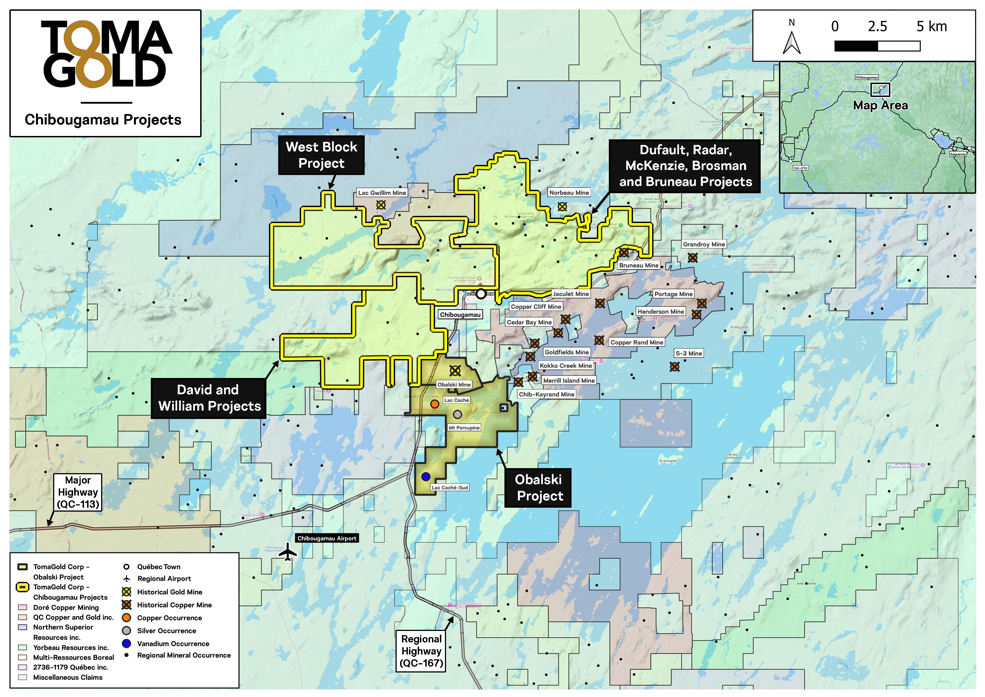
Figure 1 – Map of TomaGold’s Chibougamau Projects
David Grondin, President and CEO of TomaGold, commented: “With the arrival of Jean as VP Exploration of TomaGold, a whole new dynamic has emerged within our company. Jean, together with our technical team and external consultants, has put in place a plan and strategy to explore and develop our Chibougamau projects. These projects have been explored in the past, but with less advanced technology and at shallower depths, and are providing us with very useful data. We believe that given the Camp’s strong historical production base of copper and gold, our projects hold promising discovery potential that we intend to unlock for our shareholders.”
“TomaGold has prime real estate in the Chibougamau Camp, which hosts gold, copper, silver and zinc mineralization in multi-directional veins and massive sulphide systems,” added Jean Lafleur, VP Exploration at TomaGold. “The Camp is dominated by NW-SE veins within the Doré Lake Intrusive Complex where a total of 19 deposits were mined from 1958 to 2008, yielding over 50 Mt at 2.21 g/t Au for 3.06 million ounces of gold and at 1.83% Cu for 2.1 billion pounds of copper. Currently, approximately 40 Mt of historical mineral resources at 1.16 g/t Au and 1.13% Cu with Ag-Zn credits remain1. In addition, mineralization occurs within the northern Abitibi Greenstone Belt segment of the Camp, providing strong potential for additional resources.”
In 2025, TomaGold will focus on advancing exploration on its Chibougamau projects, with an immediate focus on Obalski, Berrigan and Radar, which are summarized below with work planned for 2025:
Obalski Gold-Copper-Silver Project (100% TomaGold)
The Obalski gold-copper-silver project (“Obalski”) is comprised of 75 claims covering 27 km2, one 85-metre shaft and two ramps. Obalski hosts nine separate Cu-Au-Ag mineralized zones – the A/A-Po, B, C, D, G, South, Beaulieu, Peninsula and Wilson Zones in the DLIC (refer to Figure 2). Historical mining yielded 110,300 tonnes at 2.08 g/t Au, 6.04 g/t Ag and 1.14% Cu from the combined A/A-Po Zone.
More than 540 holes were drilled on the project for 78,000 metres. The historical drilling was done from surface to 150 m along the 800 m SE-NW 110° mineralized corridor anomalies of the A and B Zones, also defined by InfiniTEM anomalies.
A perpendicular 020°-030° fault cuts the combined zones and adds an additional untested 500 m length that could host significant remobilized mineralization. Additional NE-SW 070° MegaTEM anomalies appear to define the D Zone mineralization off the A/A-Po Zone at the western end of the A and B Zones.
Selected results from TomaGold’s 2020-2022 drill programs:
- OBS-21-010A: 0.33 g/t Au over 54.80 m, incl. 1.44 g/t Au over 3.50 m
- OBS-21-015: 23.78 g/t Au, 16.55 g/t Ag and 1% Cu over 3.20 m, incl. 167.5 g/t Au, 11 g/t Ag and 6% Cu over 0.45 m
- OBS-21-015A: 5.06 g/t Au and 3.27 g/t Ag over 10.50 m, incl. 71 g/t Au and 31.4 g/t Ag over 0.65 m
- OBS-22-019: 1.83 g/t Au and 0.73 g/t Ag over 52.30 m, incl. 125 g/t Au, 45.80 g/t Ag and 3.30% over 0.50 m
- OBS-20-002: 47.4 g/t Au, 87.6 g/t Ag and 7.06 % Cu over 1.1 m, and 67.1 g/t Au, 40.1 g/t Ag and 2.32% Cu over 0.5 m
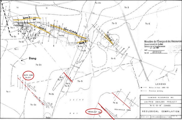
Figure 2 – Plan view of TomaGold’s 100%-owned Obalski project
Planned Exploration Program on the Obalski Project
- Compilation:
- Compiling and tying all historical drill intersections to the vein system whether NW-SE (A vein type – A, A-Po, C, G, South, Beaulieu, Peninsula, Wilson Veins/Zones), E-W (D vein type – D, B Veins/Zones) or NE-SW (DDH-OBS-88-15): 3D modeling of individual veins combined with all underground workings, including geology, surface IP anomalies and the first-vertical magnetic gradient.
- Geological mapping:
- Trenching, channel sampling and assaying on the D, A/A-Po, B, C Zones and near drill hole OBS-88-15 to define the potential of the 020-030° trend.
- Geophysical survey:
- Add an IP survey along the D Vein from SW to the NE, including the Wilson and South Zones. The plan would be to drill up 20 holes on multiple targets based on the results of the compilation work and the IP survey:
- 50-60 m below surface on the D Vein
- Infill and depth continuity of the A/A-Po, B and C Veins
- 30 m north of drill hole OBS-88-15 to define the potential of the 020-030° trend and on drill hole CB-3
- Test the Wilson, South and D Vein extensions
SOQUEM Projects (Option to acquire 100% interest)
In 2025, TomaGold will focus its exploration activities on the Radar, David and Dufault within its SOQUEM project portfolio.
Radar Project (Au-Ag-Cu-Zn)
The Radar project consists of 14 claims totaling 7.75 km2 located 3 km north of Chibougamau. The project contains the northern extension of the fracture system hosting the copper-gold structure of the Brosman deposit and the extension of a major E-W fault hosting the former Norbeau mine. An exploration ramp is present near the Belle-3 showing (BEL-7 hole: 15.9 g/t Au, 8.48 g/t Ag, 1.25% Cu over 2.25 m). The abundance of polymetallic showings (Au-Ag-Cu) and the numerous shear and fracture zones create excellent discovery potential for polymetallic vein deposits, orogenic gold and Cu-Ni-PGE ± Co. The property also has potential for VMS-type deposits in the felsic rocks of the second regional volcanic cycle.
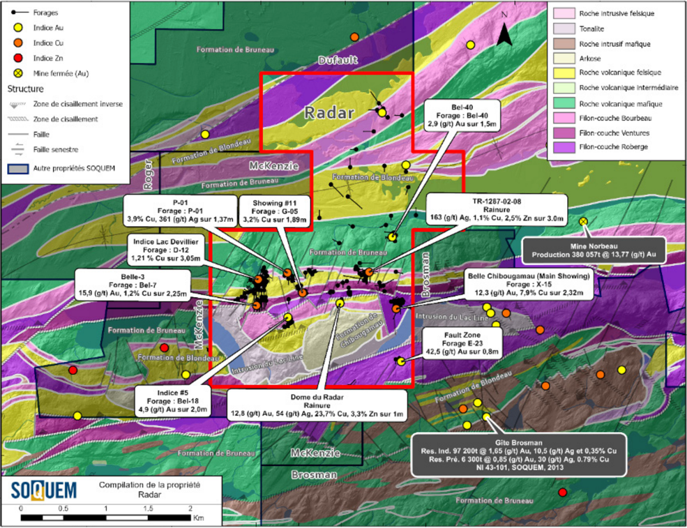
Figure 3 – Geology map of Radar project
David Project (Au-Cu-Zn)
The David project consists of 49 claims totaling 20.09 km2 located less than 2 km from Chibougamau. The project is characterized by several gold and zinc occurrences, most notably the Lac David and Lac Pierrot showings:
- Pierrot-East Lake (hole 1165-09-19): 2.0 g/t Au over 21 m
- David Zn-Au (channel): 6.2 % Zn over 1 m and 4,0 g/t Au over 1 m
- David Au (channel): 4.73 g/t Au over 1 m
The position of the project within a deformation corridor and over a transition zone between two volcanic cycles makes it a high-quality prospect for VMS-type mineralization.
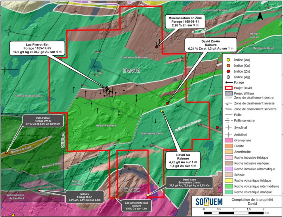
Figure 4 – Geology map of David project
Dufault Project (Au-Cu-Zn)
The Dufault project consists of 14 claims totaling 5.22 km2 located 5 km north of Chibougamau and has excellent potential for gold-copper porphyry mineralization. The MOP-II Deposit on the adjacent Roger property owned by SOQUEM and XXIX is hosted along the same horizon.
Gold-bearing intervals in drill holes 1311-02-03 (0.12 g/t Au over 124 m) and 1311-09-08 (0.24 g/t Au over 193.4 m) suggest the presence of a potential large, mineralized zone whose boundaries have yet to be defined.
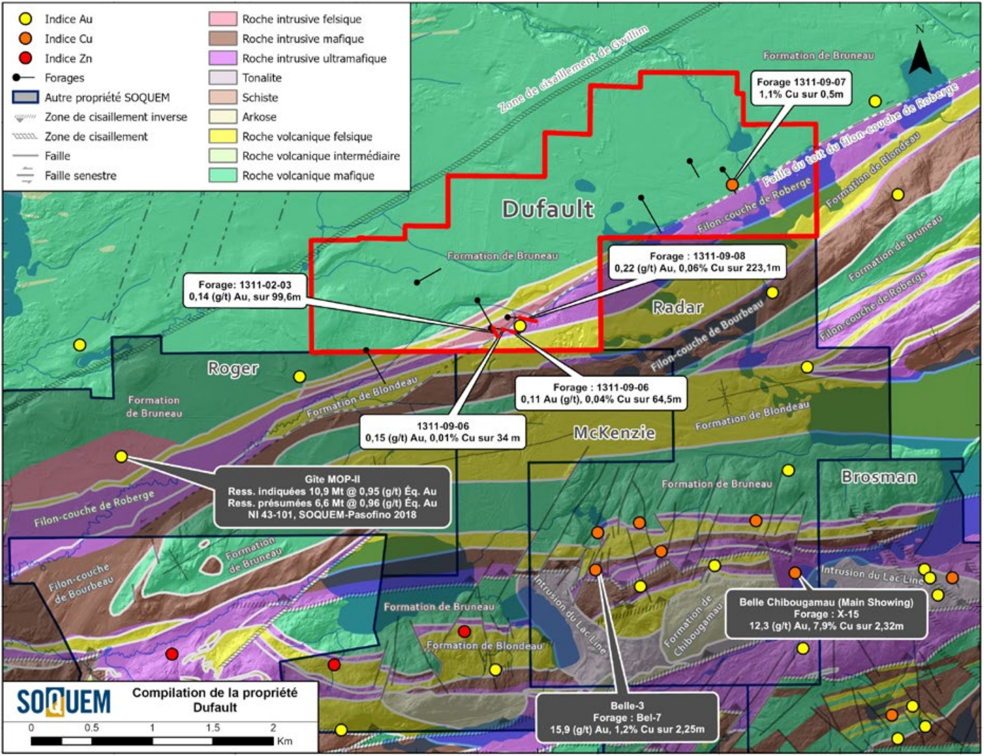
Figure 5 – Geology map of Dufault project
Planned Exploration Programs on the Radar, David and Dufault Projects
- Compilation:
- Complete compilation of drill hole database, including collar coordinates, directions, dips, lithologies, analyses, mineralization type, structure, alteration and veining:
- All with corrected UTM coordinates
- Complete the 2D geological map
- Radar project:
- Add Campbell Resources compilation from 1983-1984 to the SOQUEM (2004) database, at the same scale
- Add SOQUEM’s IP anomalies, shaded Lidar and magnetic data
- Create a 3D model for the Belle-3 ramp, Lac Devilliers and the 1207-04 drilling areas
- David project:
- Create a 3D model of drill holes with iso-contouring of the gold values:
- Add surface IP anomalies
- Best drill targets:
- Projected contacts of intermediate to mafic lithologies with undrilled IP anomalies
- Field work:
- Dufault project:
- Channel sampling of the Gap and Bourbeau Outlet Zones
- Geophysical surveys:
- Radar project:
- E-W airborne magnetic survey with maximum 50 m line spacing
- Possible 3D ambient noise tomography survey
- New IP coverage in potential areas not previously covered by F1 and Bel-40 drill areas
- David project:
- Downhole IP survey in the new and old holes selected following the 3D modeling, assuming casing left in place
- Dufault project:
- NW-SE oriented IP survey covering the 055° vein corridor passing through drill holes LD-87
- NE-SW oriented IP survey covering the fractured peridotite-pyroxenite segment of the Bourbeau Sill Outlet Zone
- Overlay IP survey results on the 1989 Westminer geology map
- Drilling:
- Radar project:
- Along the contact of the base of the Bourbeau Sill and the Blondeau Formation:
- Silver showing, hole A-1 and hole Bel-41
- McKenzie area west of Line Lake
- Untested anomalies coinciding with NW-SE, N-S, NE-SW vein structures crossing the Bourbeau Sill in the mineralized quartz ferro-gabbro
- David project:
- Below the intersection of 1.74 g/t Au over 24.0 m (Drill hole 1165-09-19)
- Beginning of drill hole 1165-09-21 below the 0.69 g/t Au over 12 m intersection
- Untested and target IP anomalies generated from the 3D modeling
- Dufault project:
- Drill IP anomalies coinciding with the 055-065° and E-W structures
CIM Option Projects (Option to acquire 100% interest)
The priority target within the CIM claims is the Berrigan claim block under the Berrigan Mine project. The project consists of 16 claims totaling 4.83 km2 located 4 km N-NW of Chibougamau.
The property has been the subject of more than one historical estimate. Met-Chem Canada Inc. prepared the most recent of these in April 2001 in a report titled, Pre-feasibility study: Etude Conceptuelle, Projects Berrigan and Tortigny by Chuinard et al. In the report, a resource estimate completed using polygonal estimation techniques stated 1,388,915 tonnes of material grading 3.17% Zn and 1.77 g/t Au on the main Berrigan Mine Zone. No resource classifications were given for the resource (Source: GM61359, Met-Chem, 2000). The mineral resource estimate above is historical and was not completed to NI 43-101 standards. The QP has not completed sufficient work to classify it as current. Significant data compilation, re-drilling, re-sampling and data verification may be required by a qualified person before the historical estimate on the project can be classified as a current resource. The Company is not treating this as a current mineral resource.
Historical drilling includes 306 diamond drill holes for 41,288 m completed by seven different companies between 1950 and 2022. Significant results from the 306 holes are listed in the table below.
Table 1 – Select intersections from historic drilling on the Berrigan Property**
| Company | Drill Hole | From (m) | To (m) | Interval (m) | Au (g/t) | Ag (g/t) | Zn (%) |
|---|---|---|---|---|---|---|---|
| Taché Lake Mines | A-005 | 131,4 | 140,2 | 8,8 | 6,96 | 5,70 | |
| 1951-1968 | A-016 | 18,9 | 21,2 | 2,3 | 6,43 | 1,51 | |
| 76,2 | 77,7 | 1,5 | 8,91 | 3,45 | |||
| A-061 | 107,1 | 115,7 | 8,6 | 8,14 | 39,70 | 6,15 | |
| A-063 | 113,7 | 114,3 | 0,6 | 49,23 | 404,64 | 17,55 | |
| 129,4 | 132,8 | 3,4 | 8,88 | 68,16 | 8,86 | ||
| A-065 | 121,6 | 125,7 | 4,6 | 6,08 | 21,56 | 7,67 | |
| 164,7 | 167,2 | 2,5 | 6,95 | 15,44 | 3,13 | ||
| A-066 | 100,6 | 101,8 | 1,2 | 36,65 | 39,73 | 22,90 | |
| 159,8 | 168,8 | 9,0 | 5,19 | 19,60 | 6,26 | ||
| A-067 | 157,1 | 158,2 | 1,1 | 10,96 | 16,75 | ||
| A-073 | 144,8 | 145,1 | 0,3 | 32,88 | 27,90 | ||
| A-084 | 130,3 | 142,8 | 12,5 | 5,10 | 17,18 | 4,58 | |
| A-086 | 50,9 | 52,1 | 1,2 | 15,07 | 59,60 | 7,00 | |
| A-103 | 56,4 | 59,4 | 3,0 | 11,61 | 5,84 | ||
| Canadian Merril | U-02 | 44,9 | 45,6 | 0,7 | 17,81 | 89,74 | 2,95 |
| 1969 | U-02 | 90,4 | 91,4 | 1,0 | 26,72 | 58,91 | 13,80 |
| U-03 | 8,2 | 16,6 | 8,4 | 6,98 | 20,71 | 13,09 | |
| U-04 | 85,9 | 86,6 | 0,7 | 37,68 | 78,09 | 7,05 | |
| Bitech Corporation | TA-87-27 | 31,1 | 32,3 | 1,2 | 17,98 | 37,33 | 5,60 |
| 1987-1990 | TA-90-50 | 65,5 | 70,1 | 4,6 | 6,78 | 10,12 | 4,12 |
| TA-90-50 | 114,0 | 129,5 | 15,5 | 8,05 | 23,58 | 6,57 | |
| TA-90-52 | 201,2 | 203,3 | 2,1 | 5,70 | 11,60 | 5,21 | |
| TA-90-56 | 164,4 | 166,9 | 2,5 | 6,18 | 5,23 | ||
| Mines indépendantes | BT-13-001 | 75,60 | 78,40 | 2,80 | 7,25 | 25,10 | 7,11 |
| Chibougamau | BT-13-001 | 105,00 | 111,50 | 6,50 | 2,39 | 13,70 | 1,72 |
| 2013-2022 | BT-13-003 | 76,80 | 77,70 | 0,90 | 16,94 | 48,00 | 9,50 |
| BT-13-003 | 141,50 | 144,80 | 3,30 | 2,28 | 20,30 | 4,43 | |
| BT-13-003 | 156,50 | 158,80 | 2,30 | 2,81 | 4,00 | 2,31 | |
| BT-13-003 | 196,40 | 197,60 | 1,20 | 4,97 | 6,00 | 1,36 | |
| BT-13-004 | 111,90 | 113,90 | 2,00 | 2,76 | 12,00 | 2,74 | |
| BT-13-004 | 133,80 | 135,00 | 1,20 | 5,92 | 20,00 | 4,20 | |
| BT-13-005 | 128,20 | 129,60 | 1,40 | 13,87 | 74,00 | 4,14 | |
| BT-13-005 | 143,50 | 144,90 | 1,40 | 2,73 | 21,70 | 3,60 | |
| BT-13-005 | 145,40 | 148,20 | 2,80 | 3,02 | 21,40 | 3,39 | |
| BT-13-005 | 153,80 | 157,30 | 3,50 | 8,12 | 44,30 | 9,15 | |
| BT-13-005 | 168,90 | 175,70 | 6,80 | 2,03 | 25,70 | 3,66 | |
| BT-13-007 | 147,00 | 154,00 | 7,00 | 2,82 | 20,80 | 4,55 | |
| BT-13-007 | 182,30 | 195,40 | 13,10 | 2,00 | 35,10 | 3,32 | |
| BT-13-008 | 152,10 | 154,60 | 2,50 | 3,72 | 16,20 | 3,14 | |
| BT‐16‐010 | 181,00 | 185,00 | 4,00 | 2,18 | 5,06 | 1,47 | |
| BT‐16‐012 | 129,92 | 134,30 | 4,38 | 6,90 | 12,09 | 2,99 | |
| BT‐16‐013 | 61,88 | 65,83 | 3,65 | 1,45 | 17,90 | 4,11 | |
| BT‐16‐013 | 79,22 | 85,00 | 5,78 | 2,03 | 8,71 | 3,50 | |
| BT-22-015 | 135,7 | 154,3 | 18,6 | 1,15 | 7,92 | 2,32 | |
| BT-22-015 | 180,6 | 203,5 | 22,9 | 2,02 | 22,46 | 2,19 |
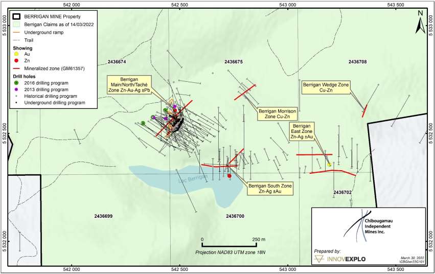
Figure 6 – Drilling map of Berrigan Mine project
Planned Exploration Programs on the Berrigan Projects
- Compilation:
- 2D and 3D modeling with drill hole database at scale and using elevation model
-
- Incorporate reprocessed historic magnetic, EM surveys
- Recompile database:
- Important to add the elevation of drill hole collar in the survey tab of the database
- Create a specific table for quartz veins to establish lateral and vertical continuity when 3D modeling:
-
- Separate gold and silver values, then another table with Zn, Pb, Co, As values
-
- Create a separate 3D Leap Frog model for the Berrigan North (Main) Zone and the Berrigan South Zone
- Geophysics:
-
- Line cutting N-S and E-W covering massive sulphide stratigraphy
- EM and IP survey – defining sulphide corridors as outlined by historical drilling
- LIDAR survey – outline structural lineaments
- Detailed surface mapping:
-
- Includes the historic outcrop stripping:
-
-
- Outline structures, alteration envelopes and geometry of mineralized zones (Berrigan Zone)
-
- Bulk sampling – 1 tonne sample from underground workings of deposit
- Examine possibility of open pit versus underground mining scenarios, leading to a feasibility study
- Drilling:
-
- Extend mineralization at depth between 250 m and 500 m depth following up of F lens (3.7% Zinc and 2.6 g/t Gold over 21 m)
- Complete in-hole EM survey to determine if any off-hole EM anomalies exist
- Exploration drilling on geophysical targets (IP and EM)
TomaGold’s technical team is already working on the compilation portion of its exploration program and intends to begin field work in the spring and continue until late fall of 2025.
The technical content of this press release has been reviewed and approved by Jean Lafleur, P.Geo., the Company’s Vice President of Exploration and a qualified person under National Instrument 43-101. In conducting the review of the properties mentioned in this news release, the Qualified Person consulted and utilized various sources of information and data, including government publications, and historical reports and data provided to him by SOQUEM and Chibougamau Independent Mines Inc. The Company has not verified all the technical data taken from these reports and sources but views the information as relevant and reliable.
About TomaGold
TomaGold Corporation (TSXV: LOT) is a Canadian mineral exploration company engaged in the acquisition, assessment, exploration and development of gold, copper, rare earth elements and lithium projects. Its primary goal is to consolidate the Chibougamau Mining Camp in northern Quebec. In addition to the agreements to acquire 13 properties in the camp, the Company holds interests in five gold properties in the vicinity of the camp: Obalski, Monster Lake East, Monster Lake West, Hazeur and Doda Lake. TomaGold also owns a 100% interest in a lithium property and in the Star Lake rare earth elements property, located in the James Bay region of Quebec, as well as a 24.5% interest in the Baird property, located near the Red Lake mining camp in Ontario through a joint venture with Evolution Mining Ltd. and New Gold Inc.
Contact:
David Grondin
President and Chief Executive Officer
(514) 583-3490
www.tomagoldcorp.com
Cautionary Statement on Forward-Looking Information
This news release includes certain statements that may be deemed “forward-looking statements”. All statements in this news release, other than statements of historical facts, that address events or developments that the Company expects to occur, are forward-looking statements. Forward-looking statements are statements that are not historical facts and are generally, but not always, identified by the words “expects”, “plans”, “anticipates”, “believes”, “intends”, “estimates”, “projects”, “potential” and similar expressions, or that events or conditions “will”, “would”, “may”, “could” or “should” occur. Although the Company believes the expectations expressed in such forward-looking statements are based on reasonable assumptions, such statements are not guarantees of future performance and actual results may differ materially from those in the forward-looking statements. Factors that could cause the actual results to differ materially from those in forward-looking statements include ability to complete the private placement, market prices, continued availability of capital and financing, and general economic, market or business conditions. Investors are cautioned that any such statements are not guarantees of future performance and actual results or developments may differ materially from those projected in the forward-looking statements. Forward-looking statements are based on the beliefs, estimates and opinions of the Company’s management on the date the statements are made. Except as required by applicable securities laws, the Company undertakes no obligation to update these forward-looking statements in the event that management’s beliefs, estimates, opinions, or other factors should change.
Neither TSX Venture Exchange nor its Regulations Services Provider (as that term is defined in the policies of the TSX Venture Exchange) accepts responsibility for the adequacy or accuracy of this news release.